Limerick City and County Council is progressing the development of the N/M20 Cork to Limerick project, identified as a priority investment in the Government’s National Development Plan 2021-2030, in partnership with Cork County Council, Cork City Council, Transport Infrastructure Ireland and the Department of Transport.
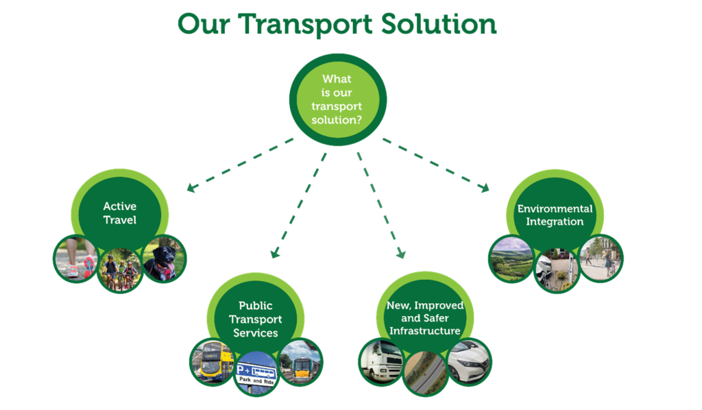
A consultation process was held in late 2020 / early 2021, that received significant public feedback on a number of road-based and rail-based options proposed and the active travel strategy. Following consideration of the public feedback and detailed appraisal, a preferred transport solution has been identified that includes active travel infrastructure for walking and cycling, improvements to public transport, new and improved safe road infrastructure and environmental integration for communities along the N20 transport corridor between Cork and Limerick.
New and Improved Infrastructure
- The N/M20 project will deliver 80 kilometres of new and improved dual carriageway road between Cork City and Patrickswell, Limerick that will provide bypasses of the towns of Mallow, Buttevant and Charleville and will reuse between 30% and 40% of the existing N20 road asset.
- The road design, including cross section, road type (Protected Road or Motorway), junction strategy and accommodation works will be developed during the next phase of the project, within the 500m wide preferred option, published on www.corklimerick.ie.
- The preferred road-based option commences from the existing N20 dual carriageway between Cork City and Blarney and then continues online reusing the existing N20 until Mourneabbey. The option then heads offline bypassing to the east of Mallow, New Twopothouse and Buttevant. The option goes online reusing the existing N20 north of Buttevant, then heads offline bypassing to the west of Ballyhea, Charleville and Banoge. The option then goes online reusing the existing N20 Croom Bypass and then ties into the existing M20 Motorway at Attyflin near Patrickswell. The preferred road-based option broadly follows the previous 2010 M20 Cork – Limerick scheme.
- The project will deliver 80 kilometres of transformative active travel (walking and cycle) infrastructure, connecting together the communities of Cork, Blarney, Grenagh, Rathduff, Mallow, New Twopothouse, Buttevant, Charleville, Bruree, Banoge, Croom, Patrickswell and Limerick.
Safety
- At least 62 people have died in the past 25 years on the N20, which has a fatal collision rate four times the national average.
- The provision of 80km of divided dual carriageway has the potential to save 200 fatal / serious injury collisions over the 30 year appraisal period.
- The provision of 80km of segregated walkway / cycleway will significantly improve safety for pedestrians and cyclists and encourage healthy active travel along the N20 corridor.
Public Transport
- The project will achieve intercity journey time savings of up to 30 minutes for express bus services between Cork and Limerick and improve journey times and journey time reliability for local bus services along the N20 corridor.
- The project examined a range of rail-based options and have recommended the development of a “no change” additional hourly rail service between the two cities, via Limerick Junction, reducing intercity rail journey times by over 20 minutes between Cork and Limerick. The new rail service is being recommended by the project team for consideration within the All Island Strategic Rail Review.
- The project will facilitate improvements to connectivity by local and express bus services to public transport interchanges (Mobility Hubs) e.g. integration with Mallow and Charleville rail stations and the proposed Park and Ride sites in Blarney and Raheen.
Environmental Integration
- Bypasses of Mallow, New Twopothouse, Buttevant, Charleville and Banoge will remove strategic traffic and heavy goods vehicles from these communities, significantly improving air quality, reducing noise levels, and further supporting public realm improvements, sustainable transport and vibrant communities.
- The National Development Plan (NDP) has been designed to ensure that it supports the Government’s climate ambitions. As a key project of the NDP, climate change considerations have been fully incorporated in the N/M20 assessment process to date. Up-to-date guidance from the Institute of Environmental Management and Assessment will be utilised to assess the greenhouse gas emissions and climate change reliance and adaptation of the preferred transport solution.
Economic Corridor
- The lack of high-quality connectivity between the regions within the Atlantic Economic Corridor (AEC) has been a major impediment to developing the regional economy as a counterbalance to Dublin and the East coast. The N/M20 project is a critical missing link from the Atlantic Economic Corridor, improving regional connectivity and accessibility along the western seaboard.
Public Consultation
- The preferred transport solution has been identified following detailed appraisal of a large number of different options and alternatives over the last three years. This process has included significant consultation with the public, transport providers, government agencies and other key stakeholders. This consultation process will continue through the next phases.
What happens next?
An online public display platform has been developed on the project website www.corklimerick.ie. This online platform will provide a virtual display room that will allow the public and other stakeholders to view and interact with the project information and maps for the preferred transport solution. The public display information and maps will also be available in the N/M20 Project Office in Lissanalta House, Dooradoyle, Limerick and a number of Council public offices and public libraries between Cork and Limerick.
Owners of property along the preferred option have been notified by post and invited to consult with the project team, either in person in Limerick or Mallow, or by online or telephone meetings during the next phase of the project. A number of public online webinars will be hosted by the project team at 7pm on the 6th and 13th April. Please click on relevant link below to attend the webinar.
Public Online Webinar – Wednesday 6th April 2022 at 7pm (link below)
N/M20 Cork to Limerick Preferred Transport Solution – Public Webinar 1
Public Online Webinar – Wednesday 13th April 2022 at 7pm (link below)
N/M20 Cork to Limerick Preferred Transport Solution – Public Webinar 2
The next phase of the project, Design and Environmental Evaluation, will involve further development of the project, including design of the road, cycle lanes and junctions, identification of the land required, detailed environmental evaluation and the preparation of an Environmental Impact Assessment Report and Business Case. Subject to Government approval, the formal planning submission is then made to An Bord Pleanála. For further information visit www.corklimerick.ie or contact the N/M20 Project Office at info@corklimerick.ie or telephone (061) 973730.