N/M20 Cork to Limerick – Public Update February 2023
Limerick City and County Council published the N/M20 Preferred Transport Solution in March 2022, following the conclusion of the Phase 2 Options Selection process. That solution was not limited to consideration of a single mode of transport but is based upon a holistic, multi modal view to improving connectivity, safety and economic links between the cities of Cork and Limerick, and ultimately Galway.
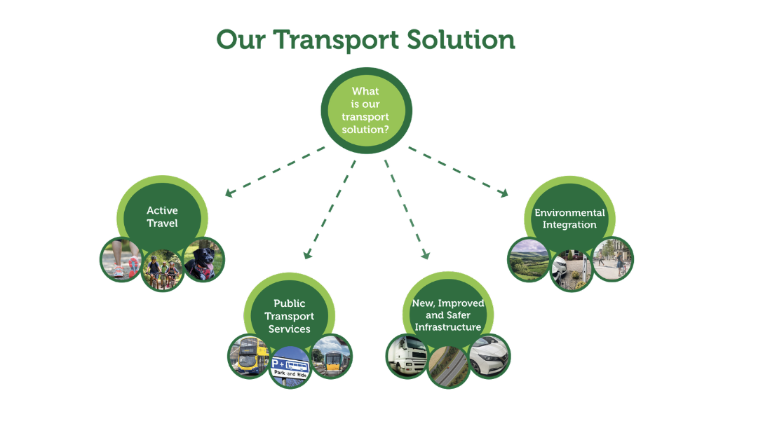
Figure 1.1: N/M20 Cork to Limerick – Our Transport Solution
The project team have continued to progress the development of the N/M20 Cork to Limerick Project and are currently progressing Phase 3 – Design and Environmental Evaluation.
Following consideration of extensive feedback received from the public and of evolving climate, environmental and transport policy, the project team wishes to update you on the following elements:
- The provision of approximately 80km of Active Travel infrastructure for walking and cycling,
- The Junction Strategy, with nine (9 no.) junction locations identified,
- The provision of Mobility Hubs at major junctions with active travel and public transport linkage,
- Opportunities to enhance Public Transport and encourage transfer to bus and rail,
- The Alternative Grey Area at Ballyhea has been removed from the study area, and
- An Alternative Grey Area at Rathduff has been included in the study area for consideration.
1.1 Active Travel
The project will deliver approximately 80 kilometres of transformative active travel (walking and cycle) infrastructure, connecting together the communities of Cork, Blarney, Grenagh, Rathduff, Mallow, New Twopothouse, Buttevant, Charleville, Bruree, Banogue, Croom, Patrickswell and Limerick.
With traffic transferring onto the new route there will be less traffic in the communities on the existing N20 making walking and cycling a safer and more enjoyable experience. The reduction in traffic will also provide opportunities for improvements to public realm within these communities.
Between these communities new shared use paths will be constructed for active travel by interlinking them, either by:
- Positioning at the edge of the new N/M20 transport corridor remote from live traffic separated by earthworks, fencing and landscaping, or
- Re-allocating road space on the existing N20 carriageway once de-classified, where traffic levels will be significantly reduced and hard shoulders will no longer be required.
Indicative routes and potential solutions for the active travel infrastructure have been shown in Figure 1.2 below.
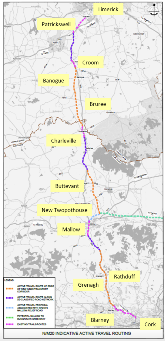
Figure 1.2: Indicative routes and potential solutions for Active Travel
Walkers, cyclists and other mobility users on these new paths will be a mix of commuter / utility trip-makers, tourists and leisure users who may choose to use the active travel network as part of a circular route.
Separately, Transport Infrastructure Ireland and the local authorities in Limerick and Cork are undertaking feasibility studies into potential Greenways between Patrickswell and Charleville and Charleville and Cork respectively. The outcome of these feasibility studies will be coordinated with the development of the N/M20 Cork to Limerick Active Travel facilities to provide an integrated active travel network. We are seeking feedback from the communities and stakeholders in respect of the proposed active travel network.
1.2 Junctions
Locations for nine (9 no.) new grade separated junctions have been identified which will provide connectivity with the communities of Blarney, Rathduff/Grenagh, Mourneabbey, Mallow, Buttevant, Charleville, Bruree, and Croom and connecting with the national primary road network at Attyflin near Patrickswell as shown in Figure 1.3.
The junction strategy for the N/M20 project has been developed taking account of:
- the existing road network hierarchy,
- settlement structures taken from the relevant development plans,
- transport modelling,
- environmental constraints, and
- feedback from the public consultations to date.
We welcome feedback from property owners and the communities in respect of the proposed junction strategy.
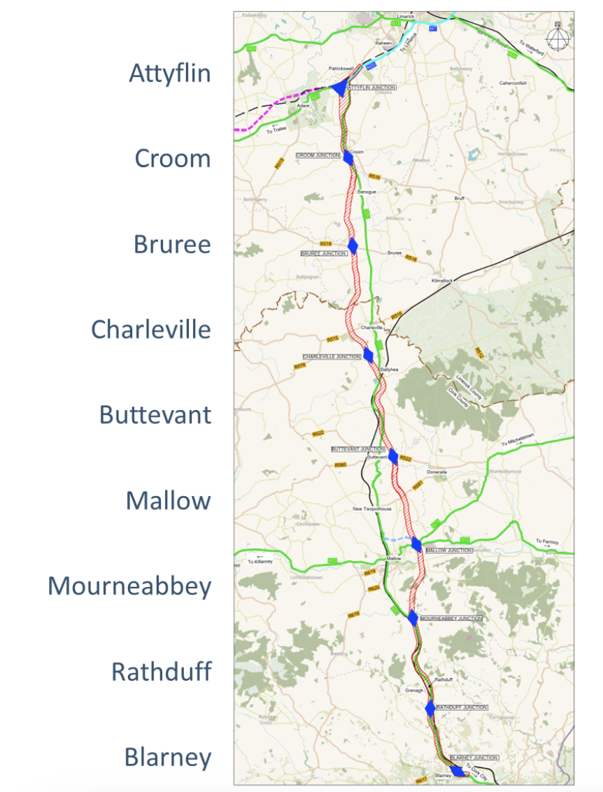
Figure 1.3: N/M20 Junction Strategy
1.3 Mobility Hubs
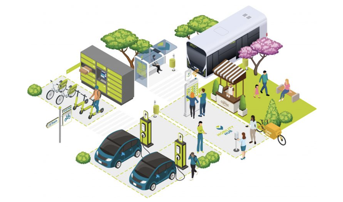
Figure 1.4: Mobility Hub Concept
The provision of mobility hubs is an integral element of the project and will be located close to the main junctions. They will enable effective active travel and public transport linkages to nearby communities, thereby offering greater travel choice and modal change opportunities. The mobility hubs would typically include secure parking areas for park and ride or park and share, bus stops and charging points for electric vehicles, including eBikes, cars, buses and trucks. These mobility hubs have the potential to provide a smart connected transport corridor linking communities and encouraging modal shift.
We welcome feedback from the communities and other stakeholders on the proposed mobility hubs.
1.4 Public Transport
The N/M20 project provides opportunities to enhance public transport services between Cork and Limerick, including bus and rail. The provision of mobility hubs will improve connectivity with and encourage transfer to public transport. The project team is liaising with the National Transport Authority, and other transport providers in relation to enhancing public transport services and connectivity.
1.4.1 Bus
Bus routes that service communities between Cork and Limerick (e.g. Bus Éireann’s 51 service) will benefit from improved journey reliability with reduced congested conditions in towns such as Charleville and Buttevant. Express services such as Citylink 251 will use the new transport corridor with significantly improved journey times between the cities and their associated airports.
The National Transport Authority’s Connecting Ireland Rural Mobility Plan proposes more frequent services (minimum service frequency of 30 minutes) on this regional corridor (Galway – Limerick – Cork) and better integration with existing services.
The provision of mobility hubs as part of the N/M20 project could facilitate a new bus service connecting the mobility hubs and the major park and ride sites at Blarney near Cork and Raheen on the approach into Limerick. This new service could integrate with the proposed Cork and Limerick Bus Connects schemes facilitating further onward travel into the cities.
Other bus companies, such as the Rural Link, could provide services between towns and mobility hubs facilitating greater connectivity for communities bordering the project.
1.4.2 Rail
Provision of a new no-change hourly rail service between Cork and Limerick was examined as part of our Phase 2 Option Selection studies.
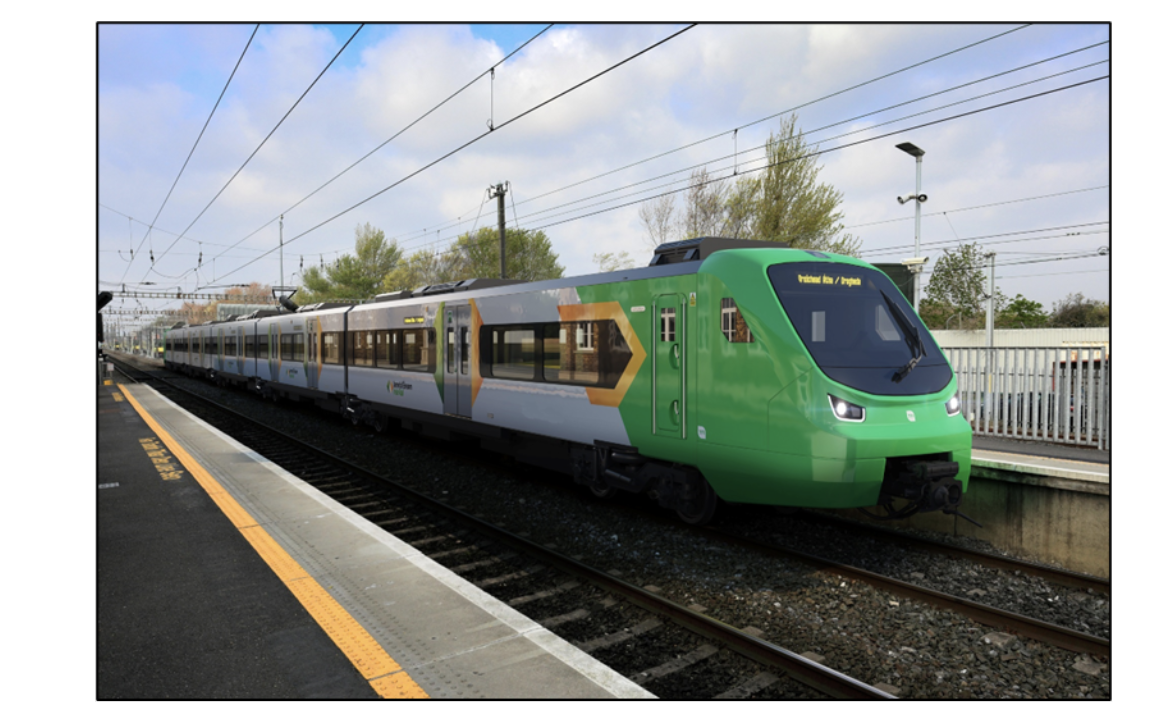
Figure 1.5: Electric Train
From our findings, we recommended to Iarnród Éireann that such a new service along the existing rail network is given consideration in the All Island Strategic Rail Review.
The appraisal process highlighted that there would be significant passengers attracted to rail and the provision of new and improved services would offer greater travel choice for inter-city journeys.
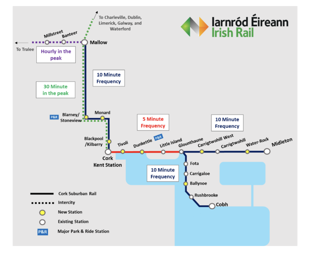
Figure 1.6: Cork Commuter Service Future Network
The Cork Commuter Rail Programme is now underway to ultimately provide a 10 minute service running through Cork Kent Station between Midleton and Mallow. The Cork Metropolitan Area Transport Study has proposed new stations at Monard and Blarney, while the Limerick Shannon Metropolitan Area Transport Study has also proposed new stations at Ballysimon and Raheen. This has the potential to lead to a greater shift to rail for intercity and commuter travel in the region.
We foresee the opportunity to extend the running of some of the new Mallow to Midleton services to form the new Cork-Limerick no-change service. Such a service could also serve the reopening of the rail station at Buttevant which would provide improved travel choice for communities along the N20 corridor.
Irish Rail are awaiting a decision from An Bord Pleanála on the Cork Line Level Crossing Project which will remove seven level crossings from the Cork to Limerick rail line. This project will improve safety and facilitate improved rail journey times. Irish Rail are also progressing a new project to increase capacity on the Limerick to Limerick Junction rail line including consideration of dual tracking of the single track sections.
The above rail interventions will improve public transport services between Cork and Limerick and the communities in between.
1.5 Refinement of Study Area
Fundamental to the assessment and development of our preferred transport solution is a detailed review of the preferred road-based option. This was presented as a 500m wide corridor with an additional two areas shown in grey, for further consideration in Phase 3, at the Preferred Option Public Display held in March 2022.

Figure 1.7: Preferred Road-Based Option
In addition to environmental survey works being undertaken as outlined below, we have been reviewing feedback from members of the public and property owners throughout the Phase 2 and Phase 3 process to ascertain key areas that the project team may be able to improve upon or mitigate against.
The project team are currently gathering information from the Environmental, Engineering and Project Liaison teams to define the route within the study area shown in Figure 1.7.
1.5.1 Alignment in Rathduff Area
Following further assessment of the preferred option in the vicinity of Rathduff and consideration of public feedback, the project team have increased the study area at this location to facilitate consideration of an alternative offline option. This increased study area is shown by the addition of a new grey alternative area located between the previously published preferred option and the Dublin to Cork Railway line as shown in Figure 1.8 below.
This larger combined study area will be examined as part of the ongoing design process, and we welcome feedback from property owners and the community prior to confirmation of the optimum route at this location.
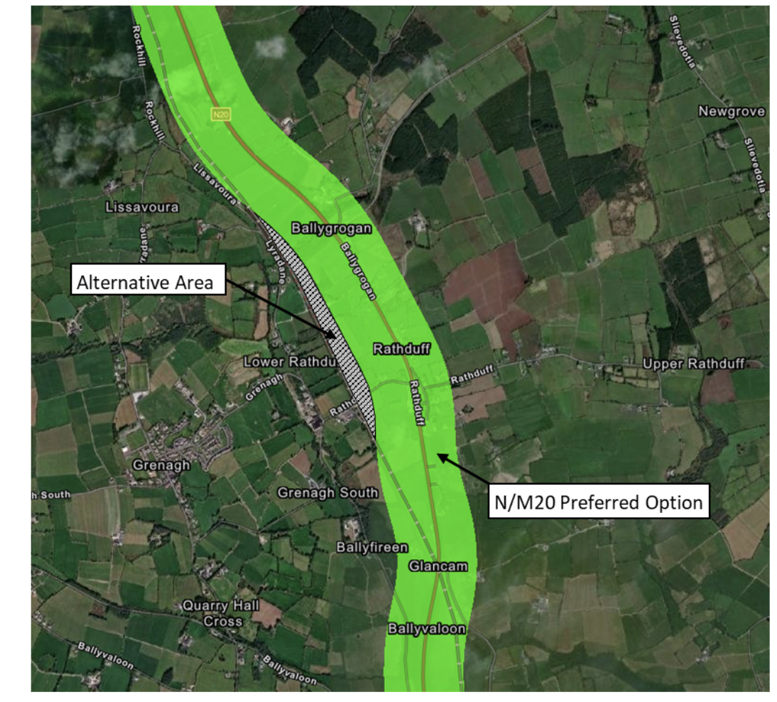
Figure 1.8: Preferred Road-Based Option plus Additional Area in the Vicinity of Rathduff
1.5.2 Ballyhea Alternative Area
A comparative assessment of the alternative grey area south of Ballyhea, as shown in Figure 1.9 below, with the preferred option was completed by the project team. The assessment confirmed that the preferred option was the optimum route in terms of engineering, environmental and economic factors.
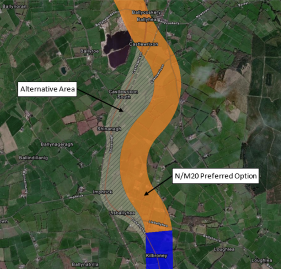
Figure 1.9: Ballyhea Alternative Grey Area
Specific assessment seeking to maximise use of the existing road in the grey area found that there are a number of constraints that make reuse and widening of the existing N20 not as desirable as the preferred road-based option.
A comparative assessment confirmed the preferred road-based option performs better for the following reasons:
- Less construction of new connector roads and realignment of side roads,
- Better use of existing N20 for serving local access and potentially active travel facilities,
- Lower impact on railway infrastructure,
- No acquisition of residential properties, and
- More opportunity to mitigate any potential noise or visual impacts that may arise.
It has therefore been concluded that the Ballyhea alternative area is not being considered further for the main alignment and is consequently removed from the study area.
1.5.3 Attyflin Alternative Area
The second grey alternative area displayed in March 2022 at the northern end of the project at Attyflin is still under consideration by the project team. Once complete, the findings of that works will be made available as part of a future public update.
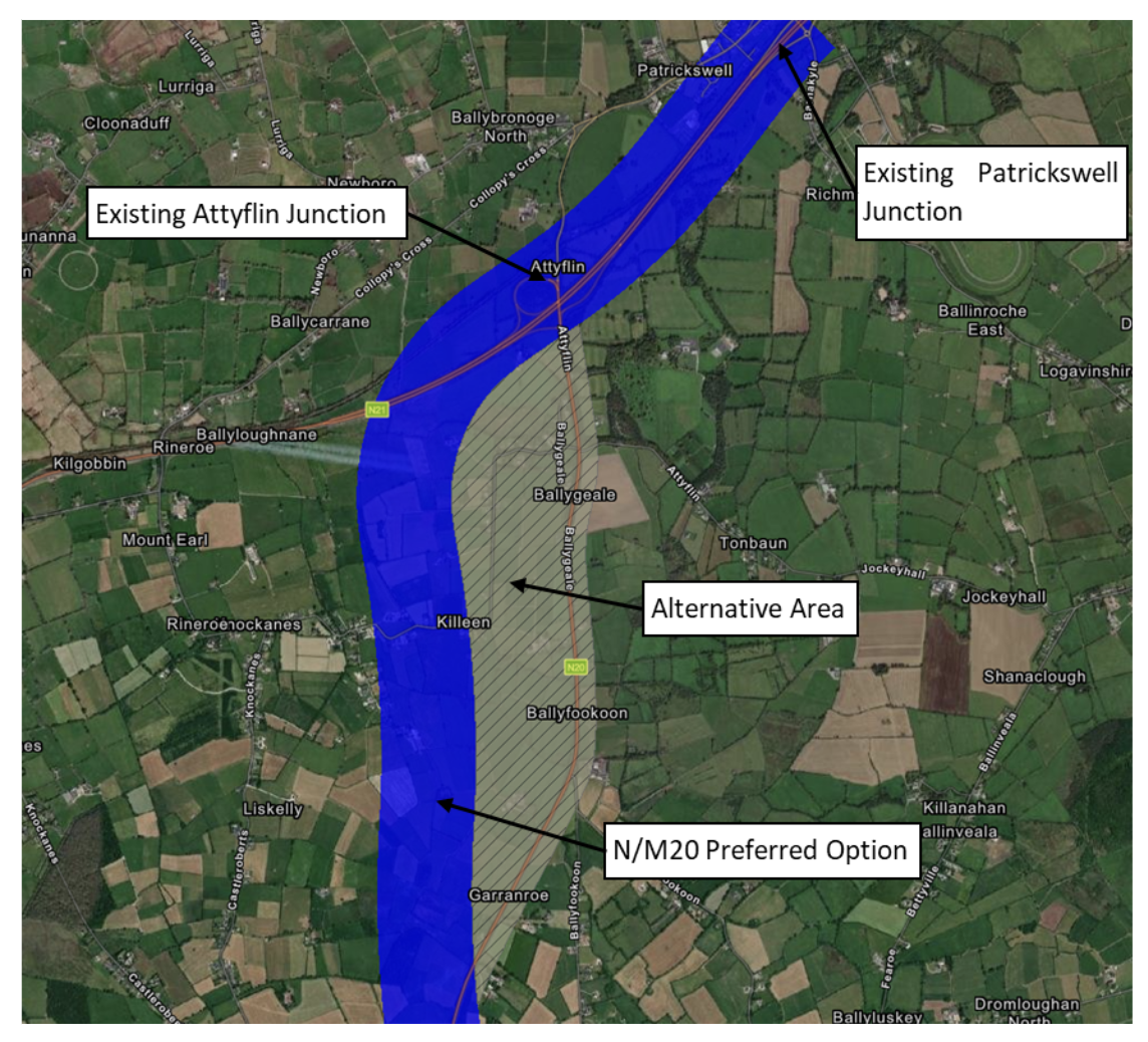
Figure 1.10: Attyflin Alternative Grey Area
1.6 Environmental Integration
In order for the preferred road-based option work to be undertaken, the project team are actively undertaking environmental surveys, including ecological, noise and air quality monitoring, earthworks site investigation works, and archaeological geophysical surveys.
Seasonal baseline studies for birds, plants, animals and ecological habitats were conducted during the summer months of 2022. Walkover transects were completed at key sites of ornithological interest and counts taken at designated locations. With the agreement of local landowner’s trail cameras were put in place to observe mammal movements at selected sites. Bat monitors, which identify bat call frequencies and the incidence of movement, were set out in tandem.
Field examination was also carried out at terrestrial and aquatic sites within Special Areas of Conservation (SACs). Much of this monitoring was completed before November 2022.
Air quality monitors were set out in the public domain at regular intervals along the route of the existing N20. This monitoring will continue until Spring of 2023. Noise monitors at private receptor locations are currently in place at agreed sites with owner permission and will remain in place until Spring 2023.
An extensive program of ground investigation was carried out during the summer of 2022 and this phase is now complete. This included a significant array of exploratory boreholes and trial pits to determine the nature and disposition of overburden and bedrock. This information is key not only to preparing an earthworks balance for the entire project but to ensure optimum use of on-site materials, and to minimise the quantity of import material and waste. Following analysis further Ground investigation may be required.
Geophysical surveys (which include resistivity and magnetometry investigations) have also commenced at potential sites of archaeological interest as identified from the LIDAR survey. Such investigations will allow the refinement of the curtilage of sites of cultural value and define subsurface areas of archaeological potential.
Our environmental specialists will continue to monitor baseline environmental conditions until December 2023. A full Environmental Impact Assessment Report will be published at the end of Phase 3. This will provide full details of all the findings from ongoing surveys and assessments.
1.7 Next Steps
Due to the ongoing development of the mainline, junctions, mobility hubs, active travel infrastructure, side roads, associated ancillary works, and environmental evaluation we will continue to require the 500m wide preferred option corridor and remaining alternative grey areas for consideration. We will endeavour to reduce the width of the study area as part of future public updates. We will continue to progress the design and evaluation of the project with further updates released later this year on our progress. We welcome feedback from property owners, communities, businesses and other stakeholders.
The project team greatly appreciate the public’s facilitation of our ongoing work and are grateful for their cooperation with the project. The above update and further details of the developing elements can be found on our project website www.corklimerick.ie and the project office can be contacted on 061 973730 or info@corklimerick.ie, for further queries, or to arrange a meeting with the project liaison team.