PUBLIC UPDATE – NOVEMBER 2023
1.1 Introduction
In March 2022 Limerick City and County Council presented the conclusion of the Phase 2 Options Selection process and published Our Transport Solution. This solution is not limited to the consideration of a single mode of transport but presents our holistic, multi modal view to improving connectivity, safety and economic links between the cities of Cork and Limerick, and ultimately Galway.
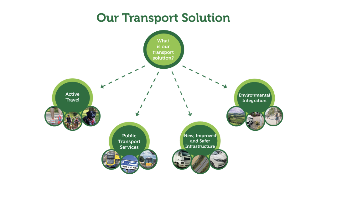
Figure 1.1: Our Transport Solution
Since the publication of Our Transport Solution, the project team have been progressing the Phase 3 Design and Environmental Evaluation stage of the project. A public update briefing was given to Elected Representatives in February 2023 with the associated information published on the project’s website.
This further update (in November 2023) explains the findings of our work over the last nine months;
- Reducing the mainline corridor width from 500m to 200m,
- Review and assessment of the alternative grey areas at Rathduff and Attyflin,
- Development of our junctions, side and link roads and reducing the area required for them,
- Further defining and extending our new active travel facilities from 80km to approximately 100km,
- Defining our unique transport hubs as an integrated key deliverable of the project, and
- Undertaking environmental based surveys and monitoring.
Central to the progression of the project is the continued engagement with landowners and stakeholders, from which the feedback has been invaluable and appreciated in undertaking both engineering appraisals and environmental surveys. As part of this public update, we are seeking continued engagement and feedback from landowners, stakeholders and members of the public and we have also developed a feedback form for consideration.
1.2 Refinement of Corridor
In February 2023 the preferred corridor was presented as a 500m wide corridor with additional alternative ‘grey’ areas at Attyflin and Rathduff, within which the design would be considered further.
The design has progressed since the commencement of Phase 3 and a reduced mainline corridor has now been developed.
Mainline Corridor
The mainline corridor has been reduced and is now presented as 200m wide shown in magenta. The centreline of the proposed road is typically near the centre of this 200m wide corridor; however, the design is still subject to refinement.
Junction Areas
In February 2023 the N/M20 junction strategy was presented, and confirmed junction locations at Blarney, Rathduff/Grenagh, Mourneabbey, Mallow, Buttevant, Charleville, Bruree, and Croom and connecting with the national primary road network at Attyflin near Patrickswell. The design of these junctions has been progressing and in addition to the refined mainline corridor, junction areas are also refined. The junction areas are presented in dark blue and encapsulate the areas where the proposed junctions will be located.
Side and Link Roads Corridor
The development of the side and link roads is ongoing and may require realignments that will be outside the area of the reduced 200m wide mainline corridor. These side and link road corridors are presented in cyan and have been developed to encapsulate the areas for potential side and link road designs.
Active Travel Corridor
Active Travel facilities will be provided along the length of the scheme. It will be provided along the edge of the proposed mainline or on parallel side roads within the reduced mainline corridor, along sections of the declassified existing N20 or along some sections of regional or local roads. Where active travel facilities extend outside the mainline corridor, junction areas or the side and link road corridors, a separate active travel corridor has been developed and is presented as a 40m wide green corridor.
Active travel facilities through built up towns and villages that fall outside the active travel corridors will be developed in conjunction with the local authority responsible for those areas.
Corridors and Areas
The corridors and areas presented do not represent the actual width required to construct the project nor the lands to be acquired, they indicate the lands within which the project will be developed. It should be noted that there may be further areas required to accommodate elements such as drainage attenuation and outfalls, transport hubs, diversion of services, temporary site compounds and habitat reinstatement or mitigation areas.
The exact details of the lands to be acquired will be established as the design develops further during Phase 3 and presented at public updates in 2024.
1.2.1 Rathduff
The existing N20 through Rathduff Village has numerous accesses and junctions serving the local community. Should the N/M20 alignment follow the existing N20 (online option), long lengths of additional parallel roads would be required to accommodate the existing accesses and junctions, as direct access will be prohibited on the proposed N/M20 mainline.
Following public feedback outlining concerns regarding community severance and the significant footprint of online infrastructure that would have been required through Rathduff, the February 2023 update acknowledged these concerns and identified an increased study area in the vicinity of Rathduff. This enabled the project team to assess an offline alternative adjacent to the existing Dublin to Cork Railway line to the west of Rathduff.
A comparative assessment of online and offline options confirmed the offline alignment performs better, for the following reasons:
- Reduced severance for Rathduff,
- A high-level environmental assessment concluded that the offline alignment has less local environmental effects,
- Existing N20 through Rathduff is maintained in its entirety with most of the existing accesses and accommodation underbridges remaining in place, and
- The removal of strategic traffic through Rathduff will allow the existing N20 to be declassified, with the opportunity for road space to be reallocated to enable active travel facilities that would enhance the attractiveness and safety of Rathduff.
Taking the offline option forward as part of the refined corridor, access to Rathduff National School and Grenagh will be maintained via the L2768 local road, incorporating a new bridge structure across the proposed N/M20 adjoining the existing rail bridge.
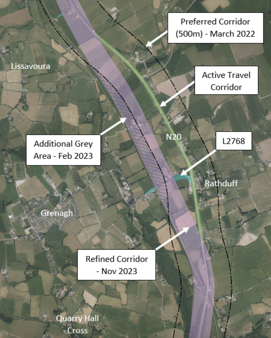
Figure 1.2: Rathduff
1.2.2 Attyflin
Attyflin is located at the northern end of the project. The alternative grey area which was included in the March 2022 Transport Solution and remained in the February 2023 public update confirmed the intent to explore options within which the design would be considered further. These options have been explored by creating three alignments and appraising their performance in respect of:
- Climate change (carbon emissions),
- Local environmental impacts,
- Engineering aspects (earthworks, structures, buildability), and
- Economics (estimated capital cost).
Each alignment is described from south to north and shown in Figure 1.3:
Option 1 – Using the preferred option corridor, Option 1 follows the route of the existing N20 from Ballyouragan until Fanningstown where it then heads northwards until it reaches its tie in point with the existing N21 corridor.
Option 2 – Follows a route immediately to the west of the existing N20 from Ballyouragan to Attyflin ensuring continued local access to properties and lands along the existing road. The existing local road at Attyflin would need to be raised significantly, where a new bridge would pass over the proposed N/M20 mainline.
Option 3 – Developed as a hybrid of Option 1 and Option 2, Option 3 follows the route of the existing N20, from Ballyouragan to Garranroe where it then follows the existing N20 northwards for approximately 1.5km. It then moves off the N20 corridor in a north-westerly direction back to the preferred option corridor until it reaches its tie in point with the existing N21 corridor.
The conclusion of the appraisal was that Option 1, which uses the preferred option corridor, is the best performing option representing best value and having the least embodied carbon emissions therefore Option 1 has been taken forward as part of the refined mainline corridor.
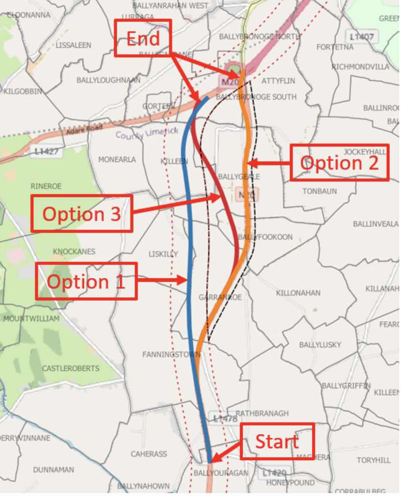
Figure 1.3: Attyflin
1.3 Active Travel
The project will deliver approximately 100 kilometres of transformative ‘shared use active travel facility (a cycle track or cycleway that is provided for people walking, wheeling and cycling)’ infrastructure, connecting the communities of Blarney, Rathduff, Mallow, New Twopothouse, Buttevant, Ballyhea, Charleville, Bruree, Banogue, Croom and Patrickswell.
With traffic transferring onto the new N/M20 route there will be less traffic in the communities along the existing N20 making walking and cycling a safer and more enjoyable experience. The reduction in traffic volumes and speed will also provide opportunities for improvements to the public realm within these communities.
Between these communities new shared use active travel facilities will be provided. The typical width of the surfaced pathway will be 3-4 metres but it may need to be less at localised pinch points. The facility will fall into one of three concepts as described below and depicted in the below graphics:
- Concept A – Located at the edge of the new N/M20 transport corridor but remote from live traffic and separated by earthworks, fencing and landscaping.
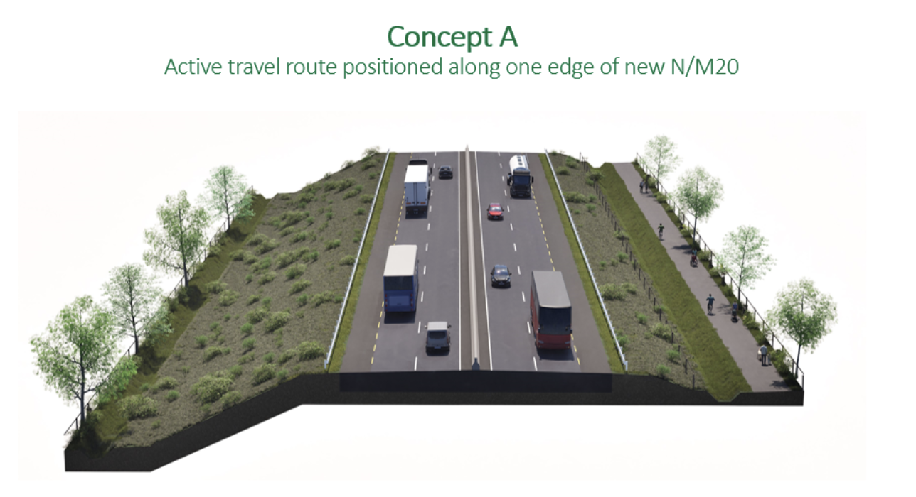
Figure 1.4: Active Travel Concept A
- Concept B – Re-allocating road space on wider sections of the existing N20 carriageway once it is de-classified, where traffic levels will be significantly reduced, speed limits reduced and hard shoulders will no longer be required.
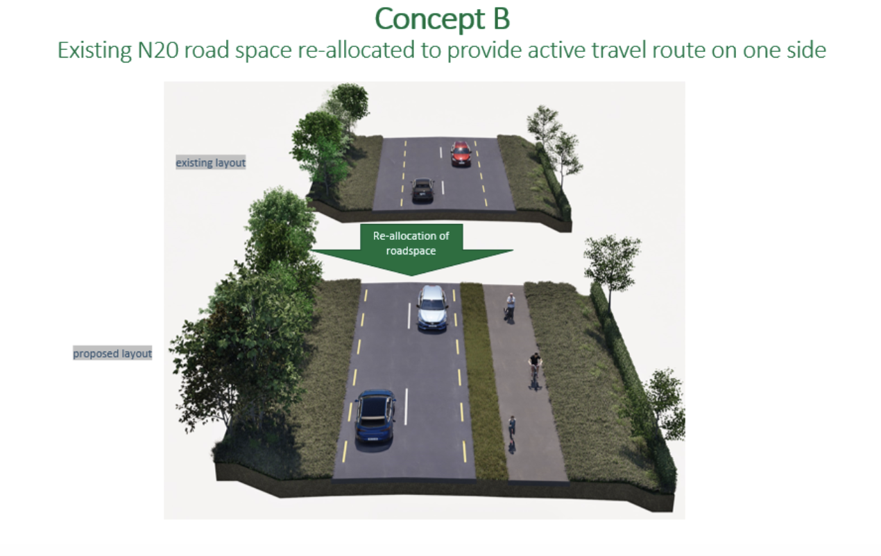
Figure 1.5: Active Travel Concept B
- Concept C – Active travel facilities along existing roads (generally regional and local roads). These roads are typically narrower than the existing N20 with sections of dense vegetation and residential boundaries close to the road edge.
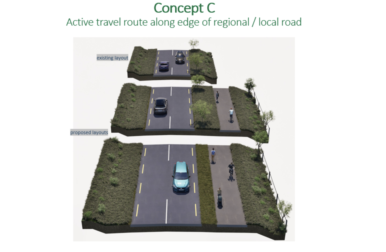
Figure 1.6: Active Travel Concept C
A high-level summary of the shared use active travel facility proposals is presented in the Developing Active Travel Proposals drawings.
Walkers, cyclists and other mobility users on these new facilities will be a mix of commuter / utility trip-makers, tourists and leisure users who may choose to use the shared use active travel facility as part of a circular route.
Separately, Transport Infrastructure Ireland along with the relevant local authorities are progressing the planning and design of the Patrickswell to Charleville Greenway and the Dungarvan to Mallow Greenway. The N/M20 Cork to Limerick project will continue to coordinate with these Greenway Projects in relation to the development of the N/M20 active travel facilities to ensure an integrated network.
1.4 Transport Hubs
1.4.1 What is a Transport Hub?
In broad terms, a ‘Transport Hub’ is any location which allows for interchange between at least two types of transport. The N/M20 transport hubs offer the opportunity for people to change to more sustainable modes, with walking and cycling routes being available to connect to public transport services. Hubs may have a range of facilities: parking, bus shelters, and electric bike and vehicle charging points. Larger hubs may provide welfare facilities such as waiting areas with restrooms. We anticipate parking will mainly be used by those wishing to transfer to bus and rail services and to a lesser extent for “park and share” activities.
Although they are traditionally situated in urban areas, the N/M20 project team have identified an opportunity to develop a network of ‘Transport Hubs’ in the predominately rural study area. The development of such a network would help to strengthen the opportunities for people living in the area to avail of bus services, park and share and new cycling and walking networks.
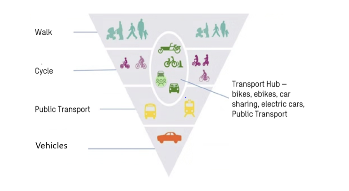
Figure 1.7: Transport Hub Sustainable Transport Hierarchy
1.4.2 Transport Hub Principles
Four key principles covering elements relating to transport integration, environment and safety ensure a user-focused, holistic, sustainable approach to our strategy. The four principles are:
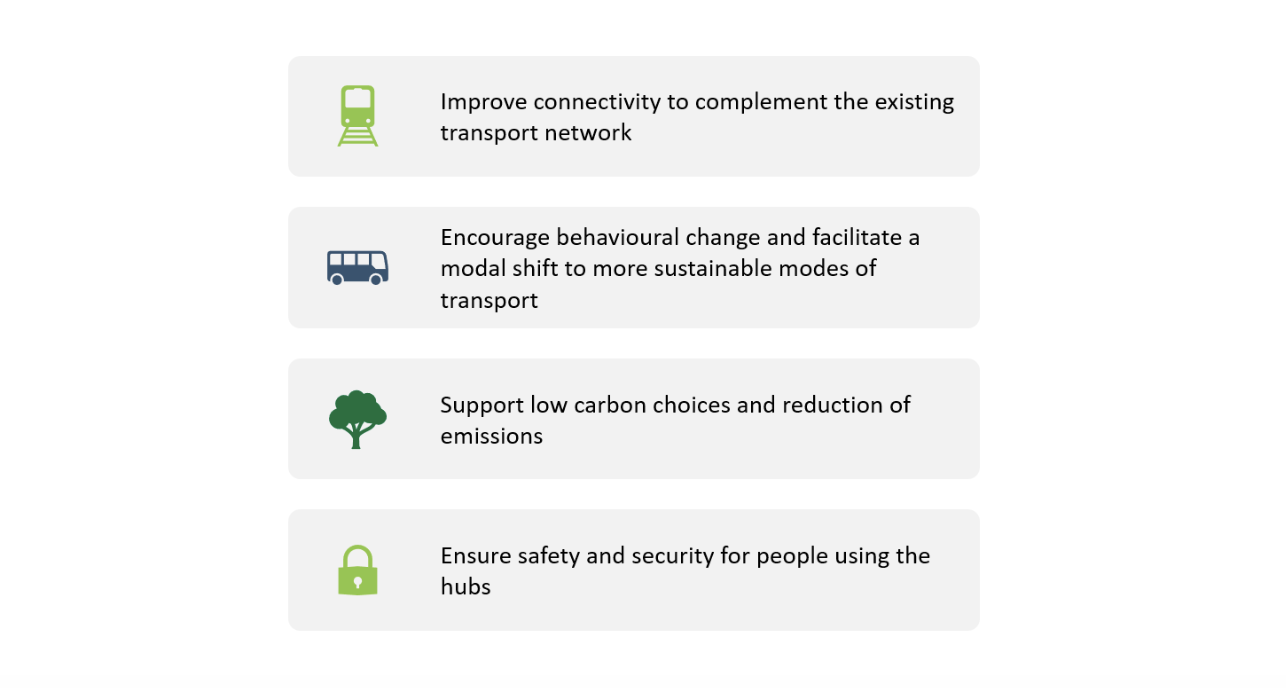
Figure 1.8: Transport Hub Principles
1.4.3 Types of Transport Hubs
The project team recognise that the services provided at each transport hub may vary across the study area. Accordingly, each hub will be tailored to ensure that it is appropriately sized and served in order to accommodate the existing and potential demands for services.
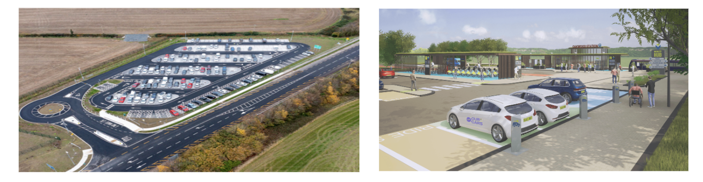
Figure 1.9: Examples of Transport Hubs
In addition to the transport hubs, a freight hub or HGV rest area, is also proposed. This is likely to be located at Charleville or Mallow. The facilities provided would include parking, welfare and refuelling facilities (including EV charging). This would fulfil the requirements of policy documents such as the European Union’s Trans-European Transport Network (TEN-T) and the Department of Transport’s Draft National En-Route EV Charging Network Plan 2023 – 2030.
An example freight hub is shown in Figure 1.10, located at the Galway Plaza on Junction 16 of the M6, which includes HGV parking, welfare and refuelling facilities.
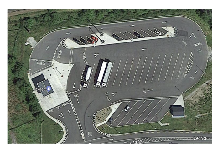
Figure 1.10: Potential N/M20 Freight Hub
The project team will develop the Transport Hubs over the coming months with your input from the feedback form, finalise the scale of Transport Hubs appropriate to each location and then undertaking a site selection process. Details of this work will be presented in the next public update.
1.5 Public Transport
As an integrated transport solution, a critical element of the N/M20 Cork to Limerick Project is to integrate with and improve access to the existing and future enhanced public transport services (Rail, Bus, and Park & Ride). We are working closely with transport providers and government agencies to explore opportunities to further integrate these transport systems for the public benefit.
The following section outlines the status of the significant public transport projects being implemented along the transport corridor between Cork and Limerick, which will improve services for existing users and encourage more people to consider sustainable public transport options. For further information on any of the public transport projects we have provided links to their project websites, where available.
Cork Area Commuter Rail Programme
Electrification and re-signalling of the three existing railway corridors in the Cork area providing a high frequency north-east connection through the city (Mallow through Cork to Cobh and Midleton). A new platform at Kent Station to facilitate through running services, increases in capacity and frequency. Additional rolling stock to meet existing and future demand. New stations and Park & Ride interchange points (including Blarney Station and Park & Ride).
Design and planning are well advanced through a series of separate but interrelated projects. The construction of the new platform at Kent Station commenced in October 2023. For further information Iarnród Éireann Projects and Investments (irishrail.ie).
Cork Line Level Crossings Project
The Cork Line Level Crossings Project identified the best approach to removing or upgrading seven level crossings located on the main Cork to Dublin line between Mallow and Limerick Junction stations. The manually operated public road level crossings are located at Buttevant, Shinanagh, Ballycoskery, Newtown, Ballyhay (County Cork), Thomastown, and Fantstown (County Limerick). The project will reduce the safety risk profile of the railway and increase operational reliability. The project will support the proposed electrification of the Dublin-Cork Railway line, which will allow for reduced journey times, lower fuel costs and reduced carbon emissions.
Iarnród Éireann has lodged a railway order for the Cork Line Level Crossings project to An Bord Pleanála, which held an Oral Hearing in September 2022, and awaits the Board’s determination. For further information Iarnród Éireann Projects and Investments (irishrail.ie).
Limerick to Limerick Junction: increasing capacity for train services
The existing single-track sections of the route between Limerick and Limerick Junction restrict capacity for services and lead to increased waiting time on the line. The initial phase of the Limerick to Limerick Junction project will review options to enhance capacity of the route through provision of double tracking. For further information Iarnród Éireann News (irishrail.ie).
Limerick to Foynes Freight Line
The 42km stretch of railway between Limerick and Foynes originally opened in 1858 but has been inactive since 2001. The line remains under the stewardship of Iarnród Éireann and will now be renewed to support the reintroduction of rail freight services on the line. The project will deliver a reliable, frequent and sustainable logistics option for the many companies that currently or in the future will use the port of Foynes. The line regeneration, while initially for rail freight services, will not preclude the possibility of passenger services being reintroduced on this line in the future subject to further infrastructure upgrades and funding.
Construction commenced in February 2023 on phase one of the project, which involves vegetation clearance and removal of existing track, replacement of the track formation, rehabilitation of bridges and culverts, installation of new rail and concrete sleepers, and renewal of fencing. Phase two of the project will include provision of signalling system, CCTV level crossings, train communications system, and track connections and upgrades at Limerick and in Foynes Yard. Subject to funding allocation for phase two, it is anticipated that the route will be open for freight in 2025. For further information Iarnród Éireann Projects and Investments (irishrail.ie).
BusConnects Cork & Limerick
BusConnects is being developed and managed by the National Transport Authority (NTA) which includes eight initiatives: Redesigning the bus network; Building new bus corridors and cycle lanes, Implementing a state of the art ticketing system; Implementing a cashless payment system; Simpler fare structure; New bus livery; New Park & Ride sites in key locations (including Blarney in Cork and Raheen in Limerick); and Transitioning to a new zero emissions bus fleet.
For BusConnects Cork, the NTA held a public consultation for the Cork Metropolitan Bus Network in June 2022. The new network will involve the creation of new bus routes and improved bus frequencies to help transform the public transport network to meet anticipated growth and future demand in the region. A second round of public consultation on the Sustainable Transport Corridors commenced in March 2023 with further consultation underway in November 2023. Technical, environmental, and transport impact assessment work continues towards submitting final plans to An Bord Pleanála for statutory approval. For further information Cork Archives | Busconnects
For BusConnects Limerick, the NTA held a public consultation for draft new bus network in March 2023. Under the proposals, the level of bus service in Limerick city and its suburbs will increase by approximately 70%. The added service levels will be enabled by the extension of bus services to new areas, more routes with frequent services, and enhanced Sunday timetable and a new 24-hour route. The network redesign will be finalised in the coming months and the new bus network will be rolled out from 2025. The urban bus fleet transition to zero emissions is underway as part of BusConnects Limerick. Electric double-deck buses are scheduled to enter service on Limerick city services in early 2024 with works underway on the charging facilities at the Limerick Bus depot. For further information Limerick Archives | Busconnects
Connecting Ireland Rural Mobility Plan
Connecting Ireland is a major public transport initiative developed by the National Transport Authority (NTA) with the aim of increasing connectivity, particularly for people living outside our major cities and towns. The plan aims to improve mobility in rural areas, and it will do this by providing better connections between villages and towns by linking these areas with an enhanced regional network connecting cities and regional centres. Following a public consultation in 2021, the NTA started implementation of Phase 1 in January 2022. Phase 2 commenced in 2023 with enhanced services being implemented by Bus Éireann, Transport For Ireland Local Link and other operators expected over the coming years.
A number of enhanced and new services are being planned and implemented within the N/M20 transport corridor including: Galway – Limerick – Cork (8); Newcastle West – Charleville – Limerick Junction (521); Tarbert – Croom (595), Limerick – Charleville (320), Mitchelstown – Mallow (523), Charleville – Mallow (522), Mallow – Fermoy – Dungarvan (9). For further information Connecting Ireland – National Transport
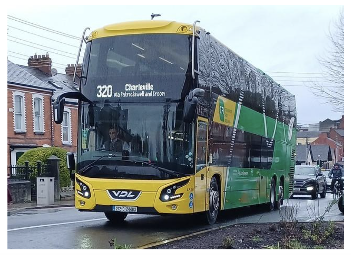
Figure 1.11: Connecting Ireland, Charleville – Limerick (320) Bus
1.6 Environmental
The environmental team are currently engaged in a multifaceted range of activities which encompass field surveys, interactions with the design team and the preparation of final project-wide and sectoral option reports.
Since the February 2023 public update, the environmental team have continued to undertake site-specific surveys and monitoring to assist in the refinement of the design. Landowners have kindly provided access to lands for walkover surveys (ecological and archaeological), for monitoring (air and noise quality), for site investigation (resistivity, magnetometry exploratory boreholes, trial pits, watercourses and topographical surveys). This fieldwork will continue for the duration of Phase 3 to ensure the environmental teams have robust data to support the decision making process and develop environmental mitigation measures.
The environmental team are an integral part of the project and support the assessment and decision making process.
The environmental team are working closely together and adapting to changes in a wide range of legislative and environmental assessment processes and guidance including, but not limited to, our understanding of climate change (in particular its adaptative and mitigatory needs) and the necessity for protection of biodiversity.

Figure 1.12: TII Carbon Tool Logo
A full Environmental Impact Assessment Report, which will provide details of the findings from these surveys and assessments, will be published and submitted to An Bord Pleanála.
1.7 Next Steps
As outlined in this public update the project team have presented a refined mainline corridor which has been reduced from 500m to 200m wide. The junctions, side roads and link roads have been advanced allowing our previously displayed land requirement for these to be reduced. Our active travel facilities have been further defined and extended from 80km to approximately 100km and we have defined our unique transport hubs as an integrated key deliverable for the project. In support of this work, we have continued to undertake our base environmental surveys and monitoring.
Over the next number of months the project team will continue to develop and refine the design of the mainline, junctions, transport hubs, active travel infrastructure, side roads, drainage, landscaping, environmental mitigation measures and the associated ancillary works. We will continue to engage with all affected landowners throughout this process to ensure they remain informed and will endeavour to minimise the potential impact the project may have on them.
It is our intention that public updates will be published in Q2 and Q4 of 2024 to inform all interested parties of our progress and the developing design of the project. Once all feedback and the final refinement of the project has been completed, submissions will be made to the relevant bodies to seek approval to commence the statutory process.
The project team continue to encourage and welcome feedback from property owners, communities, businesses and other stakeholders including all information provided in the feedback form issued as part of this update.
We greatly appreciate the facilitation of our ongoing work by landowners and the public and are grateful for their cooperation with the project. This new update and further details of the developing elements can be found on our project website www.corklimerick.ie and the project office can be contacted on 061 973730 or info@corklimerick.ie, for further queries, or to arrange a meeting with the project liaison team.